25 August 2008

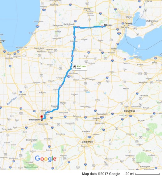
Now that I’m retired from my full time job and I can take a chunk of time away from my part time work, what would be better than a long motorcycle trip? The MotoGP race series is, for the first time ever, scheduling a race at the Indianapolis Speedway. I decide that makes for an ideal opportunity to take a very indirect route to Indianapolis for the Inaugural MotoGP race there.
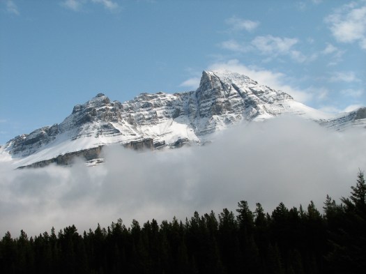
After all the time spent planning this it was asking too much to expect a good night’s sleep when the morning to leave finally arrived. I was awake early and was able to shower, breakfast, do all the last minute stuff and actually pull out by 6:30. That had the advantage of taking me through the Mojave Desert before the heat of the day. I never cease to wonder as I travel at highway speeds through the Mojave Desert, what it must have been like for indigenous peoples and early pioneers to travel through this desert on foot. They were hardier people than I am. It was good to leave the flat desert landscape and dry sagebrush behind as I followed Highway 395 through the pass between the Rand Mts and the Lava Mts at the mining towns of Red Mountain and Johannesburg.
Continuing north on 395 I watched mile after mile of igneous rock fly by and tried to imagine the scene when all that molten magma was flowing to it’s current location. The unimaginable power of the forces the earth exerts to throw up the granite mountains between which I was riding is beyond my imagination. The Owens Valley I was entering was formed by the separation of the mountains on either side of me. They were once a single mountain range that split along fault lines and separated, allowing the Owens Valley floor to subside. Across the mountains to my east lies Death Valley. Definitely not the place to be in August.
Just outside Lone Pine I stop at Manzaner, a National Historic Site memorializing what were officially called “War Relocation Centers” in the United States for people of Japanese descent after Pearl Harbor. Approximately 110,000 people were forcibly relocated to ten centers around the nation during the hysteria and anti-Japanese sentiment that followed Pearl Harbor. Abut two-thirds were US citizens. The remainder were not allowed by law to become citizens, no matter how long they had lived in the US. They were given only days or weeks to divest themselves of their businesses, homes and all their possessions before being forced into camps bringing only what they could carry.
Although none of the 504 wood and tarpaper barracks that housed 10,000 people at Manzanar are left, the cement slabs that served as foundations and the camp cemetery remain.

Many of the few remaining tombstones have origami, notes, rocks and token gifts left on them by visitors.


A single watch tower has been preserved. 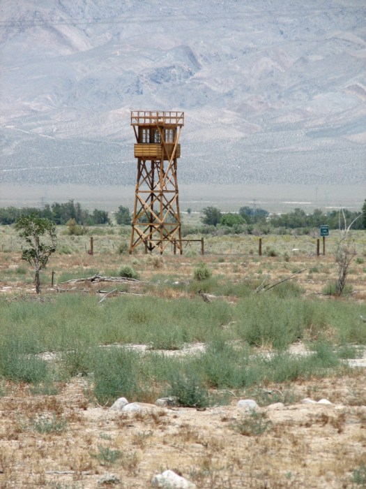 The whole experience gave me chills and drove home the point that the civil liberties we take for granted are much more flimsy that we’d like to think.
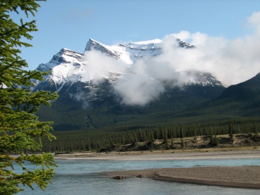
I continued north on 395 in a much more sober mood, and stopped again at Mono Lake. I’d driven by this lake countless times but never stopped. It was time to learn something about it. Mono Lake is one of the oldest lakes in North America, having existed continuously for at least 760,000 years. Runoff from the Sierras to the west bring fresh water to it, but it has no outlet except evaporation so it’s salinity level keeps rising as does it’s level of alkalinity (about 10 times the alkalinity of the ocean).
This environment is home to the alkali fly, flies that breed in the alkaline waters and live in abundance at the edge of the water. Unlike the house flies we’re used to, they show no interest in humans and, although they flew up in black clouds as I walked by water’s edge, they never went far above ground level. The local Indians, the Kutzadika’a, would harvest the pupae of the fly, peel off the outer layer and eat them. They say the pupae have a buttery, nutty, rice-like flavor. I don’t know about you, but it seems to me that whoever made this discovery had to be very hungry before trying to eat fly pupae.
The Yokut Indians traded with the Kutzadika’a for these delicious pupae and their name for the Kutzadika’a was “Monache” meaning “fly eaters”. Monache was shortened to Mono and hence the name for the lake.
The fresh water coming into the lake through springs is rich in calcium and, when it comes in contact with the carbonate-rich lake water the minerals combine to form calcium-carbonate, a form of limestone, and create the limestone towers for which the lake is famous. Many of these towers were originally underwater but beginning in 1941, the Los Angeles Department of Water and Power diverted much of the water feeding Mono Lake to satisfy the needs of a thirsty metropolis. Without water coming in to replenish water lost to evaporation the Lake dropped by 45 verticle feet and lost half its volume. Of course that meant the salinity and alkalinity doubled with predictable consequences for the wildlife that depended on the lake.


After many years of legal wrangling, in 1994, all the players fighting over the lake agreed to a lake level of 6,392 feet above sea level. This, of course, is a compromise. Higher than the current level of the lake but not as high as it was before 1941. It will take 20 to 30 years to get back to that level.
From Mono Lake it was on to Gardnerville, Nevada. My cousins, Sam and Bev have retired to this Nevada town just east of the Sierra foothills and had generously invited me to stay with them. We were able to visit and, in a lengthy phone call to family in southern California, ten of us picked players for a fantasy football league Sam manages. Wish me and my team luck. (Go Sea Slugs!!)
26 August 2008
Gardnerville Nevada is a small town. Its population is only about 3,500. What are the odds two families I know would move here? Not only did my cousins, Sam and Bev, choose Gardnerville as their retirement home but so did two old friends, Monty and Vicki who moved here from Willits, California. Well… Monty and Vicki haven’t really retired, at least not completely. Both work in Monty’s consulting business so they’re more masters of their own fate than they would be if they were employed but they do still work. We’ve stayed more or less in touch since Vicki and I worked together about 30 years ago, so when I left Sam and Bev’s I headed across town and spent a wonderful morning getting caught up with two really great people.
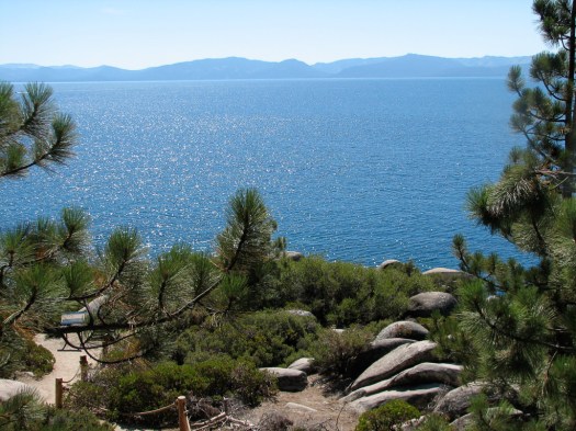
From there it was up the 395 to the 50 to cross the Sierras along the north shore of Lake Tahoe. My pace was slowed by the combination of construction and traffic but it’s a beautiful ride and I tried to enjoy it and keep my frustration at the single digit speeds in check. During a stop at Lake Tahoe I met a Gold Wing rider and we talked motorcycles. That’s one of many things I enjoy about bikes that people who don’t ride never experience. In general terms, riding a bike facilitates connections with other people the way driving a car never could.
Lake Tahoe is a beautiful high mountain lake renowned for its clarity, which decreased for many years with the coming of large numbers of humans and human activity around the lake. Its clarity is gradually being restored and is now at about 75 feet; still not what it used to be, but better than it has been.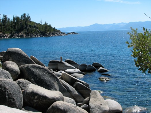
From Lake Tahoe it was a combination of freeway and local roads up to my cousins Herman and Bea in Chico, California. I once again had the opportunity to practice patience as a combination of heavy traffic and road construction kept the pace very sedate. I passed by a couple of towns that made me wonder about town names and where they come from. There’s the town of Rough and Ready. I wonder if it’s either – rough and/or ready. And then there was the town of Smartsville. Do you have to pass an IQ test to live there? Where did that name come from?
Herman and Bea are a youthful 84 and very active. Herman is a physician and still works part time so his medical license is still active. This turned out to be very convenient for me as I’d picked up an ear infection and he offered to look at it, confirmed what I could feel and called in a prescription for me. Then he took me down to the pharmacy to get it filled. How often does your doctor give you a ride to the pharmacy? So now I’m on antibiotic ear drops. Thank you, Herman!
We went by their son Stan’s to visit after picking up my prescription. He was getting ready to take his wife Sherry to a specialist the next day. She’s battling cancer. Breast cancer metastasized and she now has three brain tumors. I promised I would be praying for her.
27 August 2008
This morning Herman and Bea’s other son, Mark came over to the house so we could visit and we had a great conversation, getting caught up a little.
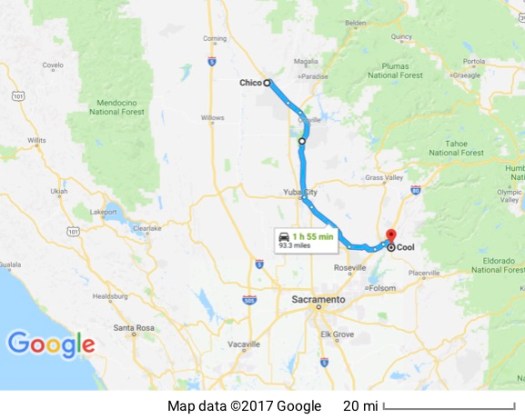
Although it doesn’t make much sense in terms of trip planning, I had to go to Chico yesterday if I wanted to see Herman and Bea because they need to go to the Bay area for a wedding tomorrow. So now I’m heading back south, retracing some of my trip to Chico to go see Tom and Lisa in Cool, California. (Another one of those great town names.) The route to Cool from Chico is just a short hop but it includes an absolutely wonderfully twisty section of Highway 49 coming out of Auburn that goes through forest, down the side of a canyon, across the American River and back up the opposite canyon wall. A wonderful motorcycle road.
Tom and I used to work together and he with his wife Lisa have retired to the foothills east of Sacramento. He and Lisa made time and space for me and I enjoyed being able to have the time to build on our relationship.
28 August 2008
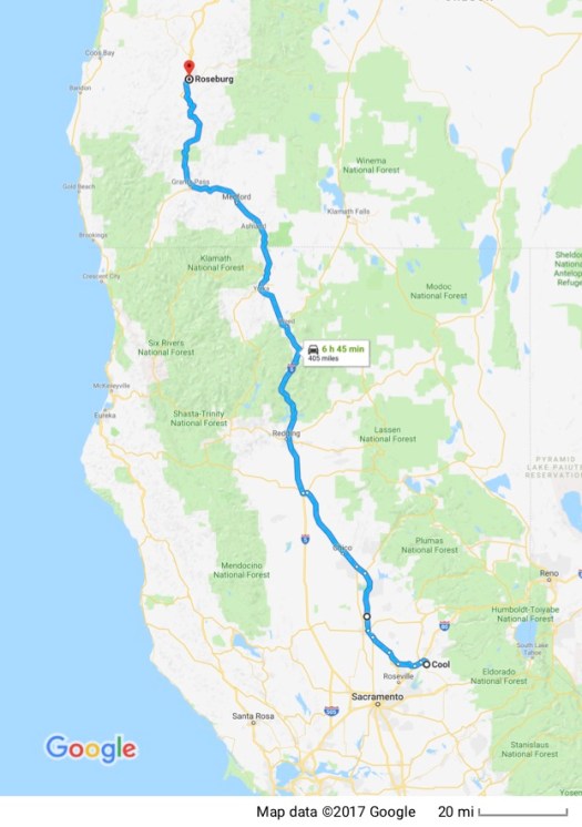
Today the plan is to travel to southern Oregon. After taking advantage of some more of Tom and Lisa’s graciousness and hospitality in the morning I leave Cool and put about 400 miles on the bike over mostly freeway miles. Passing through Chico (again) I note that all my sweat glands seem to be in good working order. It’s 111 degrees F! Whew!! I’m very grateful to start up into the mountains, traveling past Mt. Lassen, a dormant volcano, which is now a national park and looks a lot closer than it really is due to its size, and through the forested Whiskeytown-Shasta-Trinity Recreation Area. Those are actually three separate lakes with surrounding recreation areas and I pass through the Shasta Lake area.
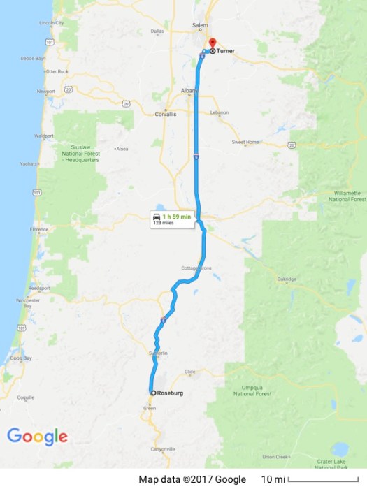
Not much farther north and I cross the border into Oregon. Initially it’s still mountainous but the landscape soon levels out and I’m passing through lush farmland. One of the joys of riding a motorcycle is the fact that you’re much more a part of your environment instead of passing through it in an insulated bubble. The varying smells of forest and field add to the enjoyment of the ride. Soon I’m exiting the freeway at Roseburg, winding my way through town and following a road that parallels a stream to my cousins Larry and Marie who live on the top of a hill outside town.
Their home is a real getaway and you start to get that feeling just driving up their driveway through the tunnel of over-hanging tree branches. I’m not sure how much land they have but it’s several acres a good part of which is forested. Larry and Marie and their three kids are open, loving and generous and seem to enjoy the steady stream of friends and relatives that take advantage of their idyllic home and their gracious hospitality.
29 August 2008
Although Larry initially thought he’d have to be at work today he ended up with the day off so we’re able to spend some more time together talking and getting caught up. Larry takes me on as his partner and we challenge Marie and their son Michael to a game of horseshoes. I haven’t played since the last time I was there a couple of years ago so, to put it nicely, I’m a bit rusty. Larry and I manage to pull it off and beat Marie and Michael.
I take my leave and head on up I5 to the booming metropolis of Turner, Oregon. Ken and Norma have retired to this small community and live in a beautiful home on a hilltop with a very large deck that looks out past stately trees with a year-round creek to a grand vista of small farms with mountains in the distance. It’s a rough life, having to put up with a view like that. My heart goes out to them.
Ken and I worked together for probably close to 30 years and have watched each other’s kids grow, leave the nest and, in Ken’s case, have kids of their own. We have a great time catching up with each other and generally agreeing that, although we’re plenty busy, retirement is definitely better than work.
The first part of this trip is mostly about staying in touch with friends and relatives rather than touring so I don’t have much for you in the way of pictures and “travel” type information. That will change. But looking back over who I’ve been able to see I’m reminded of how very, very blessed I am to have such great family and friends who welcome me with open arms whenever I show up and treat me like royalty. I treasure these relationships.
30 August 2008
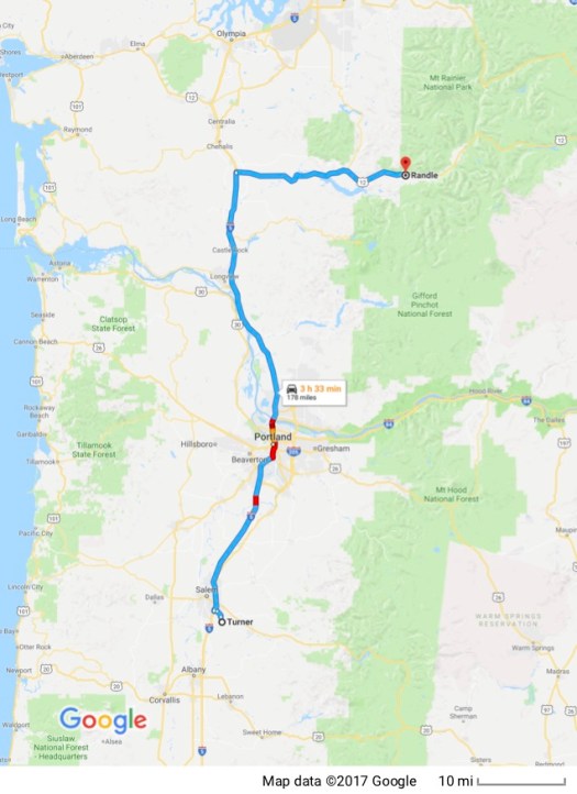
Ken, Norma and I spend some more time this morning visiting before I leave to continue north. I head on up I5 to Portland where I look up my friend Frank. We originally met at a motorcycle event about four years ago and discovered that, not only do we have motorcycles in common but we also have a similar work background. Frank is one of those people it’s hard not to like.
We sit out on his front porch, enjoy the day, catch up with each other a little and I take advantage of his knowledge of local roads and motorcycles to discuss my route north. He has some recommendations and offers to ride with me.
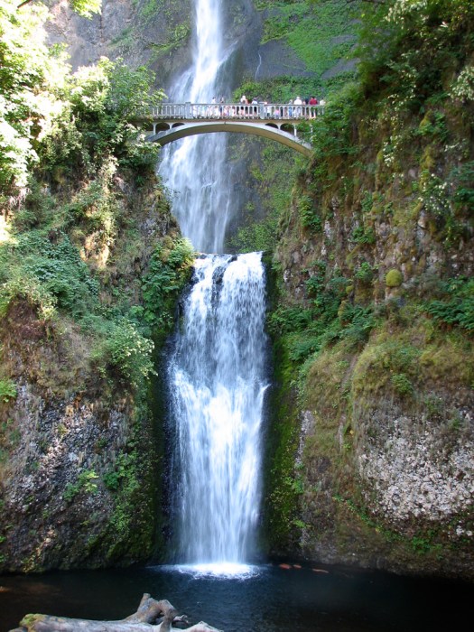
We leave his home and go past Multnomah Falls on the I84. This has to be one of the most beautiful falls around.
We cross the Columbia River into the state of Washington at the Bridge of the Gods and I watch a barge through the metal grating of the bridge as it navigates the Columbia. On the other side, we follow a wonderfully twisty two lane road up into the mountains that skirts along the east side of Mt. St. Helens. 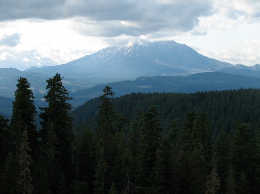 It’s hard to believe it’s been 28 years since it erupted. Frank tells me that, due to the heavy snows this last winter, the road that leads up to Mt. St. Helens is still closed. To this southern California boy, that’s amazing. This is the end of August and the road is still closed due to snow! That probably explains the fact that when I reach the closest point to Mt. St. Helens it’s only 46 degrees F. I brought along electric clothing but I’m not wearing it because I didn’t expect it to get this cold this early in the trip!
Frank and I part company at an overlook with a great view of Mt. St. Helens, the top of which is shrouded in clouds. He heads back home to Portland and I continue north enjoying being off the freeway as the bike does its ballet through dense forest and I try to keep a sharp eye out for deer; deadly animals when they leap in front of a motorcycle. It’s dusk and this is prime time for deer to be out.
I’m a little apprehensive about finding a place to spend the night since it’s Labor Day weekend and most campsites have been filled. I pull into a National Forest Service campground but make a quick U turn when I spot the “campground full” sign. I continue on toward the town of Randle and just west of Randle I check out a campground a few miles south of Highway 12 – the Cowlitz Falls Campground. They initially tell me they only have RV sites with hookups but after verifying I’ll only be there one night and that I’m alone (not the advance party for a large group of motorcycles) I take their last open tent spot which is only available for the one night. It’s an absolutely beautiful spot.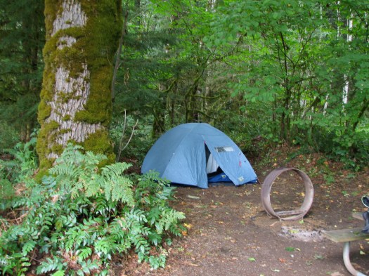
31 August 2008
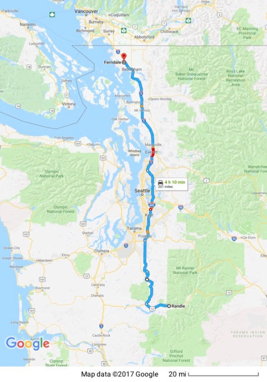
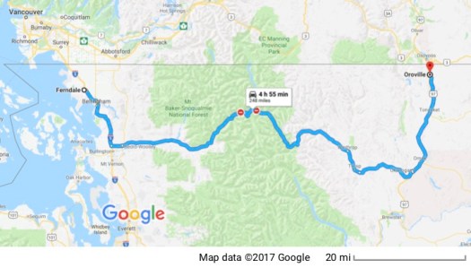
When I wake up in the middle of the night I hear rain on the tent. I’m grateful to be dry but also know that means I could be packing up the motorcycle and riding in the rain tomorrow. The day, however, starts out cloudy but no rain. I get the bike packed and leave, heading for the northern Washington town of Ferndale just south of the Canadian border where friends Gary and Diane live.
I continue on roads Frank recommended and am rewarded with more beautiful twisty roads through forest and farmland. Along the way I’m joined by a group of riders. The lead rider is on an ST1300 (the same bike I ride) with British Columbia plates followed by two Gold Wings and an ST1100, all with California plates. The ST1100 is farkeled (modified) to the max. We ride together until I drop out to gas up and find a Starbucks to try to access the internet to upload this. Starbucks’ wi fi access hasn’t been cooperating with me and this time is no exception. I type this into a Word document to be copied and pasted later when I have internet access and head back out.
Once I’m past the congested urban environment of the greater Seattle area I once again revel in the open fields of farm and range. I see herds of cattle, flocks of sheep and… alpacas. What’s a group of alpaca? A herd? A flock? A school? Why does the English language have different words for groups of animals, I wonder. Why should dogs run in a pack but fish swim in a school? It sure makes it hard when you have a group of animals like alpaca that you don’t know the right word for.
I arrive at Gary and Diane’s beautiful home which is situated on several acres in the country outside Ferndale. Much of the land has been cleared but they also have some forested land. It exudes peacefulness, which, combined with their graciousness and generosity makes for a very pleasant evening catching up with each other as they show me a little of the nearby city of Bellingham.
1 September 2008
After breakfast (with fresh local blackberries and raspberries!) Gary and Diane took me for a brief tour of the area. They’re in the country with lots of local farmers who sell their products (produce, cheese, etc.) directly from their farms. Food just doesn’t get any better or any fresher than that. Even with an influx of “foreigners” (retirees who are attracted to the area) the local residents accept the newcomers and have retained their values of community with neighbors helping neighbors. The area is a mixture of farming community and, since it’s right on the coast, a seaside community.
There are numerous islands in the area (on the US side, the San Juan Islands) and since Gary is a boater he’s able to tell me about many of them. There’s even a point of land (Point Roberts) that I’d never heard of that is only accessible through Canada if you enter by land. The Tasawwassen Peninsula juts south from Canada and the very tip goes south of the US/Canada border which follows the 49th parallel. It is, therefore, US territory. And about 1,300 people live there. If you access the point by boat you never leave the US. If you access it by land you have to go through all the Canadian border checkpoints and then back through US border checkpoints to get to the tip of the peninsula. And then reverse the process to return to mainland US. I can’t imagine how complex it must be to deliver services to this tiny spit of land — utilities, postal service, emergency medical aid, law enforcement, etc. etc.
After my brief tour and education I say goodbye to Gary and Diane and leave with presents: a chunk of Ferndale Gouda cheese and a copy of Diane’s book. I find a Starbucks and am able to upload all the blog entries I had been saving locally on my laptop. I’m farther into my day than I wanted to be. I had planned to cover more miles than I’ll be able to complete in what’s left of my day.
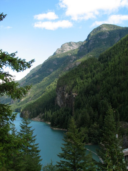
I head south to Highway 20. This is a wonderful road that crosses the Northern Cascades, going through heavily forested, mountainous terrain. The mountains are steep-sided with jagged tops, attesting to their comparative youth (in geological terms). They haven’t been worn down much yet and water from unseen glaciers and snow-pack tumbles down rivers and waterfalls into lakes that have that teal color characteristic of glacial melt.
I keep moving to try to get as far as I can before nightfall.
Signs along the route ward of a heavy wildlife presence and they show current annual and year-to-date numbers for wildlife killed by vehicles. I do NOT want an encounter on the motorcycle as there’s a good chance the animal wouldn’t be the only one killed or injured so I try to strike a happy medium between making good time and traveling at a speed that will allow me a fighting chance of stopping in time if a deer jumps out in front of me. I do see lots of deer and a doe, followed by two fawns, cross the road right in front of me.
Nowhere near my hoped for destination, I start looking for a camping spot and find a campground in the Osoyoos State Park on Lake Osoyoos. I pick a spot across from a couple of Harley riders who are setting up their tent they wave and, after I have my tent set up I wander over and we talk. They’re Canadian heading into the US for vacation and we discuss each other’s intended routes and destinations.
2 September 2008
Instead of entering Canada through the Kettle Falls area, as planned, I enter at the Osoyoos entry point. I had more riding in Washington planned but I’m behind schedule so I’m trying to make up a little time. I only have to travel a few minutes to get from my campsite to the border where I wait in line for the single open border station. When I get to the window I meet what has to be one of the most bored officials anywhere. Every question he asks me is said in a quiet voice while he looks at his computer screen, away from me. Those of you who know me, know I have a hearing loss. Whenever I ask him to repeat the question he never turns his head to speak in my direction, he never raises his voice, he simply continues to repeat the question at the same volume and continues to talk to his computer instead of talking to me. I end up leaning my head through his window to be able to hear him. That doesn’t seem to bother him since he isn’t being required to change anything he’s doing and he eventually returns my passport to me and allows me to proceed.
I make a quick stop at an ATM to withdraw some Canadian currency and head east on Canadian Highway 3. A well constructed road with sweeping turns that parallels the border. I stop for breakfast at a small cafe that turns out to be a favorite hangout for Canadian motorcyclists. There must be a dozen of them that come and go while I eat and many of them talk about their planned trip south and ask about my plans. It seems that we all want to tour the country we aren’t from. All the Canadians are going to the US. I think I’m the only American and I’m going into Canada.
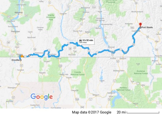
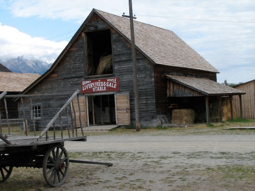
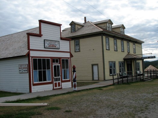
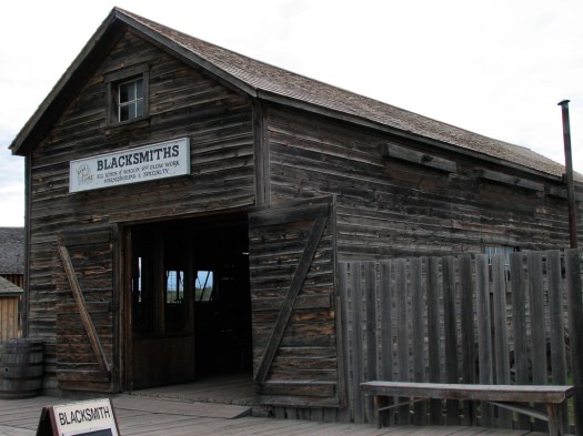
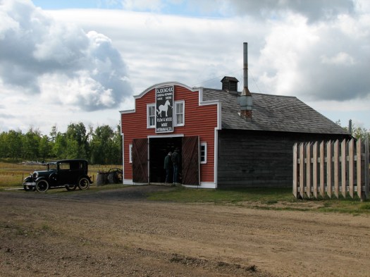
My plans were originally to visit three Canadian parks and I’d been warned by a Canadian friend that it would be a very full day. Since I’m starting out farther away I’m not at all sure how far I’m going to get. As it turns out, not far. I make it to the first park and that turns out to be much bigger than I’d anticipated. Fort Steele is a Heritage Town, in much the same vein as Williamsburg in the US. An entire town built in the middle to late 1800’s during the Kootenay gold rush. 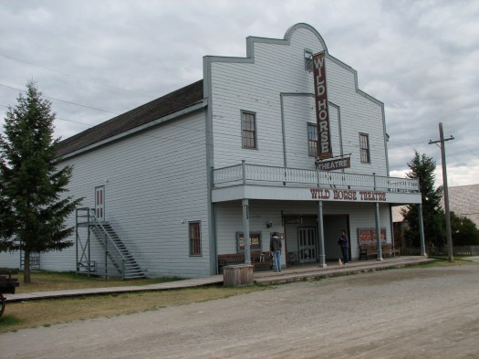
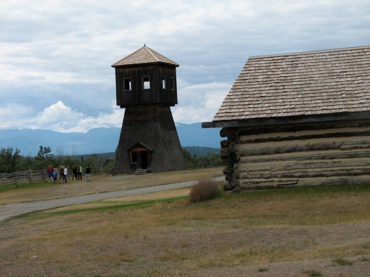
 It became a fort when the local Indians objected to what was happening as settlers flooded the area and the Northwest Mounted Police were called in to settle matters, which they managed to do peacefully.
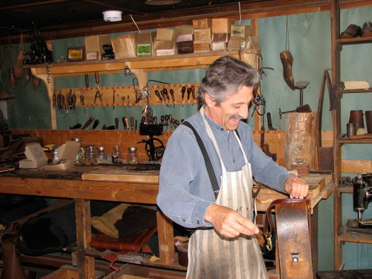
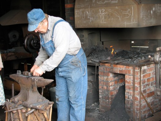
Like Williamsburg, craftspeople populate the town and ply their trade as they would have in the 1800’s. I discover that the harness maker is a former motorcycle racer with the Canadian Motorcyclist Association, racing first motocross bikes then road racing. We have a lengthy and enjoyable conversation about motorcycles while he works on a harness.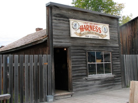
It’s late enough now that I decide to skip my planned trip to the National Park, Head-Smashed-In. I wanted to go because I just loved the name. It’s a buffalo jump that aboriginal peoples used for thousands of years to herd buffalo up a rise and off a cliff to their death; easier than chasing them down and killing them one-at-a-time. The name supposedly comes from a young Indian brave who wanted to watch the buffalo from the base of the cliff as they came spilling over the top. Some landed on him and smashed his head in.
The history of Western Canada parallels very closely that of the Western US. The pictures could easily have come from a Western town in the US. I find a campsite across the street and put in a call to a motorcycle friend to make plans to ride together tomorrow.
3 September 2008
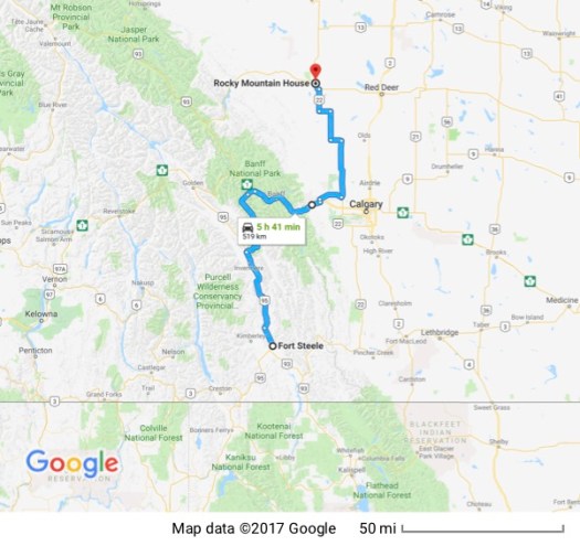
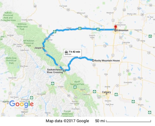
I packed up my home onto the motorcycle and put in a quick call to Steve. He had worked on times and distances and would ride up into Banff National Park from his home in Sundre and I’d head up from Fort Steele through the Kootenay National Park and on into Banff. We arranged to meet at Castle Junction around noon.
I headed north, stopping to buy gas in the town of Radium Hot Springs; the name testimony to the geologically active nature of the area. Radium is a beautiful, if somewhat touristy town just outside the entrance to Kootenay National Park. I stop at the entrance to the park to pay the entry fee then proceed through narrow canyon walls into the park. There are periodic rain showers but I prepared for that probability when I left camp so I keep going. The overwhelming, and very sad impression I’m left with of Kootenay is kilometer after kilometer (I’m in Canada — everything’s in metrics) mountainside after mountainside covered with dead trees. I’ve seen the results of the pine beetle or bark beetle in my local mountains in San Bernardino County. But there it’s a mixture of live trees and dead ones. Here they’re all dead. Later, after I meet Steve, he tells me that the dead trees could be harvested for lumber; the lumber is still good. But with the housing collapse in the United States the market for building materials has also collapsed and there’s no market for all the lumber. So all the dead trees just cover the mountainsides. Steve also said that one of the reasons for the proliferation of the beetle is the fact that the last number of years it hasn’t gotten cold enough for long enough to kill the beetle. In the past winters were colder which controlled the beetle.
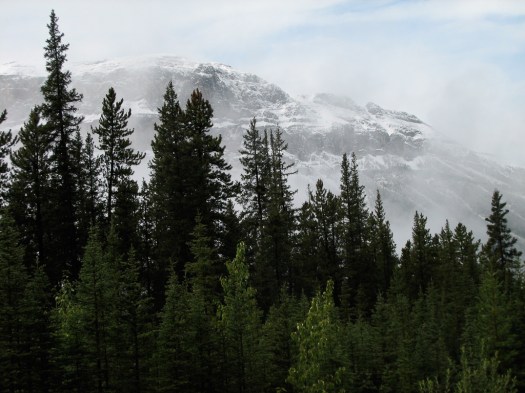
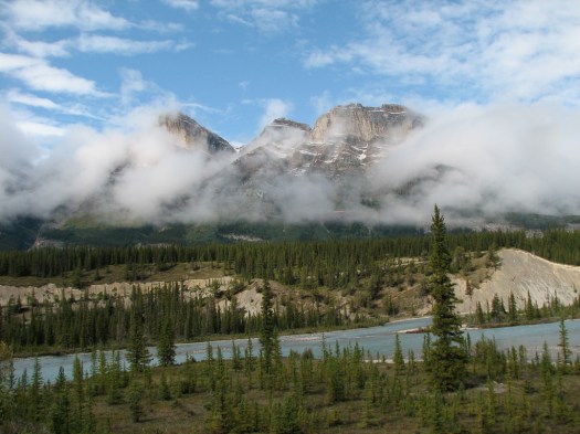
Steve and I meet at Castle Junction and ride together up the Icefields Parkway. It’s cold and rainy and as we ascend the rain turns to snow. The temperature gauge on the bike says it’s 2C (36F). Once again I’m grateful for the electrics but disappointed that clouds are hiding the scenery. Eventually the weather lets up and Steve is patient with me as I continually pull over to try to capture the majesty that surrounds me. This absolutely is overwhelming beauty that the camera cannot begin to capture but here are some of my attempts.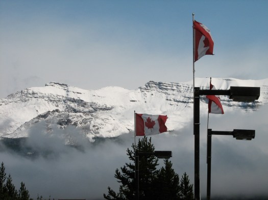
We leave the park on Highway 11. Steve will continue on home to Sundre and I pull off between the towns of Rocky Mountain House and Caroline to the home of friends Don and Paddy
4 September 2008
My friend Don and I used to be co-workers. His wife is Canadian and wanted to move back to Canada so Don retired and they now live in a rural area of Alberta where Don is establishing his career as a sculptor. I was excited to be invited to visit and was really looking forward to seeing his studio and his work. Unfortunately (for you) he asked me not to take pictures of his works in progress so the only pictures I have are pretty generic. He sculpts the life-size and larger-than-life-size sculptures that are cast in bronze and displayed in parks, libraries, government buildings, etc. The first picture is of Don working on what will be the head of a twice-life-size sculpture of a cowboy.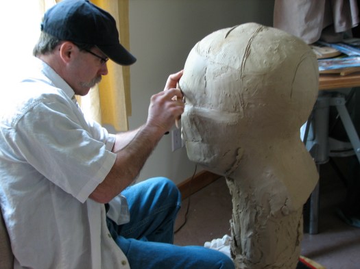
I can tell you from seeing his work that, even though it’s not finished, it’s just amazing. He’s doing another one of a World War II Japanese aviator and obtained a uniform (shown hanging on a coat rack) that he had a model wear, then took pictures from every possible angle. 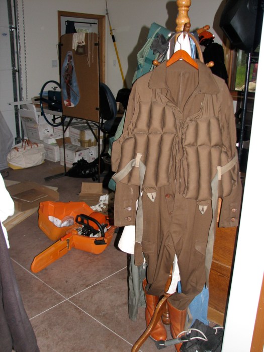 He’s amazingly detail-oriented and is able to translate that detail into an oil-based clay which is then taken to a foundry to be cast in bronze.
All over the walls of his studio are medical charts detailing the musculature of males and females, skeletons, torsos, and anatomical studies. Here’s a picture of clay faces detailing how the face changes as we age. There’s also a block with differently shaped ears that you can see.
I wish I could have shown you more of his work. It really is amazing. Don is currently working with officials to line up work in his new locale in Canada and the cowboy is part of that. I had a great time visiting with both Don and Paddy (and their cat Belle) and got to use Don’s computer to upload entries for this blog, pay bills, answer email, and do other internet chores. I also was able to work a little with Don as he cut down a couple of dead trees on his property (he has almost 5 acres) and added an accessory to his table saw.
5 September 2008
After breakfast with Don and Paddy I’m back on the road. I backtrack to the west to reenter Banff National Park where Steve and I exited the other day. I then continue my trip north on the Icefields Parkway. It’s cold, which I expected, but it’s also totally overcast and intermittently showering. (At least it isn’t snowing this time.) The clouds obscure the mountains so I don’t take any pictures. Even though it’s late in the season, cold and rainy, there’s a never-ending stream of tour buses. As I watch them drive the Parkway and disgorge their occupants at scenic spots (that are obscured by clouds) I wonder what the guides are saying… “… and on your left, behind those clouds, is Mount something-or-other with a beautiful waterfall. You’ll just have to take my word for it.”
I do stop at the Athabasca Glacier. This glacier is (fairly) easily accessible from the Parkway. It’s been retreating for years and, since the late 1800’s has lost 60% of its mass. They have cement markers denoting where it was in different years and it’s easy to see a steady retreat. So I have to climb the terminal moraines (the large piles of rubble pushed ahead of the glacier as it flows down a mountain and left behind when it retreats.) Motorcycle boots and cold-weather motorcycle gear isn’t the most efficient clothing to go hiking and climbing in.
I make it to the toe of the glacier, however and take a few pictures. They weren’t worth the effort it cost me to get them; especially since I didn’t have the common sense to take a hat with me. It wasn’t raining when I got there so I didn’t think to take it. Of course after I’d climbed all the way up to the glacier it started coming down pretty steadily, soaking me. I didn’t have a thermometer so I can’t give you numbers but my seat-of-the-pants estimate is that the wind coming off that glacier and blowing across my rain-soaked head was somewhere south of what would be classified as a tropical breeze.
Just to give you an idea of the scale of this thing – This picture shows the toe of the glacier and its lateral moraine. (The pile of rubble pushed off to the side of the glacier.) The height of the lateral moraine shows the former height of the glacier. About half-way up the moraine in about the middle of the picture you can see a couple of little white dots. Those dots are full sized tourist buses taking tourists higher up the glacier.
There is also a picture where the ice at the toe has broken away and you can see the blue color of the interior of the glacier. 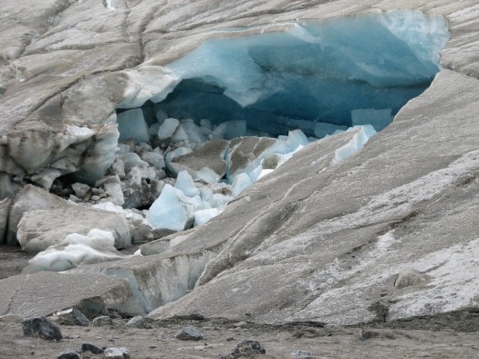 This glacier is one of many that flow down from the Columbia Icefield. This icefield feeds rivers that flow into three oceans: the Arctic, the Atlantic, and the Pacific. Amazing.
When I crossed the Bridge of the Gods outside Portland, some of the water that was floating the barge I was watching pass underneath me had come from the Columbia Icefields.
As I continue my journey up the Parkway, I parallel the north-flowing Athabasca River which will eventually empty into the Arctic Ocean. I continue north to Jasper then east on Highway 16, finding a place to camp for the night just east of Edmonton.
6 September 2008
When I wake up this morning, there isn’t a cloud in the sky and it looks as if it’s going to be a beautiful day. I take the rain covers off my bags, break down the tent and pack everything away on the bike. While I’m doing this a couple of neighbors, two men with a two-year-old boy come by and we talk for a while. They’re interested in the bike, where I’m from and where I’m going. They assure me that the weather will be unpredictable and, sure enough, before I can leave there’s no blue sky to be seen anywhere. I take the rain covers back out of their backs and reinstall them.
As I’m riding off, one of the men comes out of his campsite and flags me down. Apparently they’d gone back to their site and told their wives, “That poor guy is going to freeze to death.” The wives want to know, “what poor guy?” and after they explain that there’s a guy on a motorcycle, “…and he’s from California!!” the wives send them back out to invite me to share their breakfast with them. (I guess Californian’s have a reputation for being winter wimps.)
I accept and thoroughly enjoy scrambled eggs with onion and tomato in little tins that have been cooked over an open fire they have going. There’s also coffee, ham and toast… quite the feast. (I enjoy thawing out by the fire, too!) After breakfast they all gather at the edge of their camp to watch me get into all my gear and see me off. I’m very very grateful for their wonderful generosity.
I find my way back out onto Highway 16, which, while it isn’t known as the “Yellow brick road” it is called the Yellowhead Trail, named after the Yellowhead Pass in the Rockies. And, no, I don’t have a clue why the pass was named “yellowhead”. I do wonder about it, though. The symbol, found on signs all along the route, is a silhouette of a head that’s colored…. you guessed… yellow.
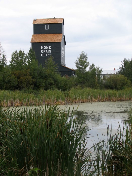
Not far down the road is another heritage village. This one is for the Ukrainians. I decide to take the time to stop and see what it’s all about. I learn a lot. Apparently there is a very large Ukrainian population in the farming areas of eastern Alberta, Saskatchewan and Manitoba. I had no idea. According to a couple I met several days later, there was some fear in Canada that the Americans would sweep into the comparatively unoccupied plains areas of Canada and take them for the United States, much as they had done to Mexico’s territories that later became the American West.
So Canada was offering free or very low-cost land. This sounded irresistible to Ukrainians who were living in abject poverty under almost feudal conditions in Ukraine and they came over in droves in the late 1800’s and early 1900’s, bringing with them, as all immigrants do, their religion, customs, language, dress, culture, etc. and formed their own tight-knit farming communities.
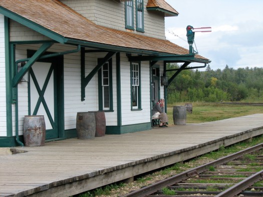
The village is comprised of actual Ukrainian buildings from multiple Canadian towns that were moved to this site. They started out as subsistence farmers, but with the advent of trains for transport and grain elevators for storage, they could change to cash crops which fueled greater economic prosperity.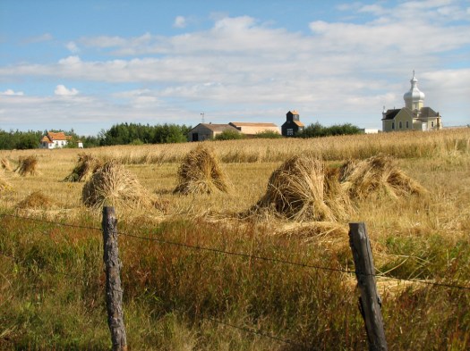
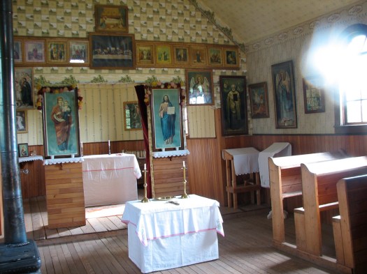
I would see these Ukrainian Orthodox churches scattered all over Alberta, Saskatchewan and Manitoba in the coming days. 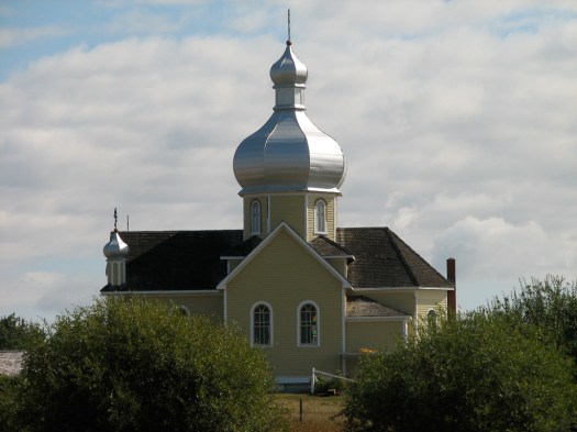 My guide explained to me that a wealthier church like the first one pictured, could afford to hire an official iconographer to paint the icons on the interior of the church walls. For this church the process took over a year of steady work, which is highly regulated.
 There’s also an example of a smaller, poorer church that could only frame pictures and hang them up instead of having icons painted on the walls.
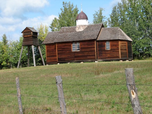
The hotel had an interesting story. 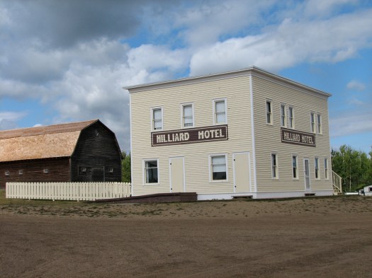 Under the law, beer could only be served at a hotel. Bars weren’t legal. The hotel had to have a certain number of rooms for guests and it had to have a kitchen and dining room. So this hotel was built in complete compliance with the law. It had all the requisite rooms, furnishings, dining room, kitchen, etc. But, it never had a single paying guest and almost never served any meals out of its kitchen. Little farming communities aren’t noted for attracting tourists that need hotels. It did, however, serve a lot of beer to local residents.
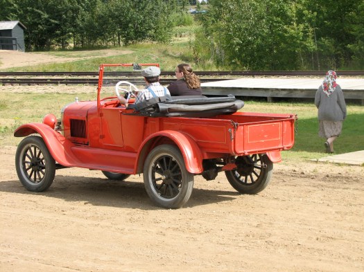
I spent a lot of time here. They had gone to great effort to create an entire village and give it the feel of a real working farm community.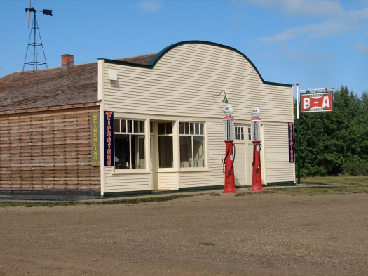


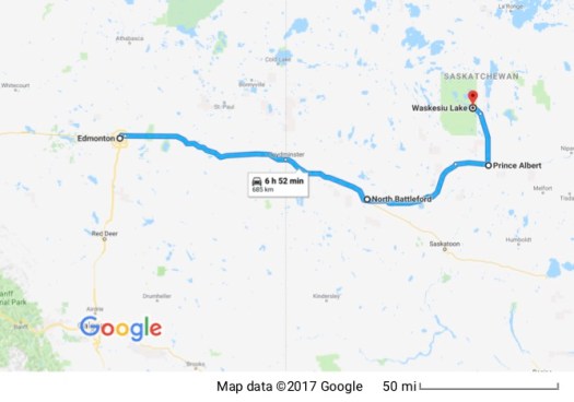
I get back on my bike and head back out on the Yellowhead Trail. I follow it out of Alberta into Saskatchewan before I head north and continue east on Highway 40. This is a much smaller two-lane country road and I pass a number of Ukrainian communities (identified by their Orthodox churches with their distinctive architecture). I stop for dinner in one of those little farming communities and, much to my surprise, find a Chinese couple who run a very rundown little restaurant selling Chinese food and hamburgers. I try the ginger beef which really isn’t bad then continue my ride until I pull into Prince Albert National Park just as it’s getting dark. I quickly get my tent set up by a lake and crawl in for the night.
7 September 2008
It’s off to Manitoba today so I leave Prince Albert without being able to explore the park. It’s a beautiful forested area with lakes and rivers and I’d love to come back when I can stay for a while but today I need to make it to Riding Mountain National Park in Manitoba if I’m going to make it to Indiana on time.
After going south out of the park, I head east on Highway 3. This starts out as a small country road, passing through more farming communities, and shrinks to a tiny country road. It’s Sunday so there’s probably less traffic than there would normally be on a weekday, but I’m going through little villages where I don’t see a living soul and I’m only meeting about one other vehicle per hour on the road. It occurs to me that if I were to go off the road and into one of the weed filled ditches it would be a very long time before I was discovered. The way the weather is going it might not even be until after the spring thaw.
The Canadian geese all seem to be responding to the weather, too. I see many heading south. There was one flock, however, that seemed somewhat confused. It was a flock of maybe 75 birds or so, in two of their classic “V” formations, but they were flying north. I watched them as long as I could and they never veered off their course which was due north. I know what you’re thinking and, yes, it really was north. I even checked my sense of direction against my GPS. They were flying north. Every other flock I saw was going south, except for this one. Maybe they didn’t get the memo.
Another puzzle (for me) is, many of the fields have evenly spaced structures, mostly in a beehive shape, frequently painted red. They’re maybe 5 or 6 feet tall and 4 or 5 feet in diameter. They all have a fairly large opening in one side and the opening always faces the southeast. I can’t see that there’s anything inside any of them so their purpose remains a puzzle for me.
From Highway 3 I go south on Highway 10 through heavily wooded areas to Riding Mountain National Park. Based on the signs, a primary use of the park is for cross country skiing in the winter. There are lots of signs for skiing trails. There are also lots of signs to watch for Moose. If running into a deer can kill a motorcyclist I can’t even imagine what hitting a Moose would be like. Maybe I could duck and just go under its belly.
I camp in a campground next to Clear Lake but all the tent sites are closed. All the campsites here are closing for the winter and they’re almost deserted. Most places I have the pick of the sites. Here I have to set up my tent in a pull-through for RV’s because that’s all that’s open. I guess they don’t figure that anybody’s going to be dumb enough to camp in a tent in this weather.
8 September 2008
As I enter a restaurant for breakfast this morning a man comments on my bike and we have a brief conversation before he invites me to join him and his wife at their table. I’ve said it before but I love the way riding a bike facilitates connections with people. That would absolutely never have happened if I drove up in a car.
It turns out that he’s also a rider and a local pastor. We have a great conversation over breakfast and he suggests some great local roads for me to ride on my way. I see the roads but don’t have time to take them. I need to cover more kilometers today than a leisurely, zigzag ride will allow.
I’m back on Highway 16, which merges into the TransCanada, Highway 1 in about the middle of Manitoba. Although it’s a four lane, well-maintained road it isn’t a freeway and goes through towns, with all their stop lights and traffic so I’m slowing to the official limit of 60 kph or less with every town. Before I get out of Manitoba I stop to take a picture of another common sight. Many fields have little run-down ramshackle shacks, whose purpose I can’t imagine.  While the bike is parked and I’m taking a picture a man in a pickup stops to make sure I’m not broken down, and there’s nothing wrong. It turns out he’s a motorcyclist, too so he wanted to check on my welfare when he saw the bike parked by the side of the road.
The terrain changes noticeably as I cross into Ontario from Manitoba. (Unfortunately, the weather doesn’t change much.) There are lakes galore. Many of the lakes have numerous little islands, all of them covered with trees. Frequently I’m riding on what seems to be a causeway, with a lake on either side of me.
With all the camping I’ve been doing I’ve gotten way behind on blog entries, so I decide to come in out of the rain and get a motel room where I can plug in the laptop and type up these entries. The internet connection is sporadic so I don’t know exactly when I’ll be able to upload but at least everything’s typed up. I’ll try from the lobby in the morning. My cousin Laura’s husband, Lynn, is from Michigan and he’s given me the number for his mother and brother, both of whom I’ve met at family events that bring them out from Michigan. Since I’ll be passing through their neighborhood (well… their state) I give Roger a call and he invites me to spend the night when I come through. I’m grateful for the offer and will take him up on it in a couple of days.
9 September 2008

After breakfast at the motel this morning I set up camp in their lobby to upload these entries to the server and get a much better connection than what I could get in my room last night. Even though the alarm went off at 6:00 am by the time I shower, shave, eat, pack, and do my uploading it’s 10:00 am before I actually pull out. Later than I wanted it to be but it feels good to have the blog more up-to-date.
I’m a slow learner so when it’s warm and the sky is cloudless I put away my rain covers and electrics before gassing up and getting back on the road. There aren’t as many lakes near the road here but it’s beautiful forested gently rolling hills. I do find a lake nearby, though that’s worth stopping to look at, though.
I go through the occasional small town. Entering Ignace I notice that the sign welcoming me has been slightly modified. It used to say population 1500. Somebody pasted a “1” over the final “0” so now it reads 1,501. I guess in a small town the birth of a baby is a noteworthy occurrence and they wanted to announce it to everyone entering the town. Congratulations to whomever it was. They seem very proud of the event.
Even out here when I approach a town there are billboards announcing the services in the town ahead. They’re smaller, farther back from the road and sometimes not as “professional” as the huge billboards I’m used to in my urban environment. Much less intrusive visually and, if there have to be billboards, I appreciate the difference.
Once, however, one of these billboards really caught my attention. I was riding by at speed and couldn’t read it all. It occurred to me (when it was too late to do anything about it) that I should have turned around and gotten a picture. It was what seemed initially like a normal advertisement for a restaurant hawking their “family” restaurant with “home cooked” meals… common… maybe even standard stuff. What caught my attention was along the side of the billboard it advertised “worms and leeches”.
I didn’t go into the restaurant to check it out when I passed it, but I assumed it did double duty as a restaurant and sold fishing supplies. I’m not a fisherman. I know worms are used as bait. Are leeches? I can’t imagine any other reason (except humorous ones) for a restaurant billboard to advertise worms and leeches.
Since I have a long way to go to get to Roger and Jane’s home I want to get as many miles as possible under my belt. My plan is to stay on my current route and follow the north shore of Lake Superior, leaving Canada through Sault St. Marie. However, when I enter their address in the GPS when I’m approaching Thunder Bay it suggests a route directly south into Minnesota. I decide time is of the essence here so I’ll follow the route picked out by the GPS.
The GPS routes me away from the main highway and Thunder Bay onto some very small country roads. I’m low on gas, though so I have to backtrack to Thunder Bay to get gas. After getting gas and heading south again the sky looks dark and foreboding to the south so I stop to put the rain covers on my gear. I look up to see a couple, each on their own Gold Wing, who were going north and stopped on the opposite side of the highway to check on my welfare. I give them a thumbs up and they wave and continue north.
I cross the border into Minnesota without incident and discover I’ve returned to Central Time. I had changed all my clocks to Eastern time when I entered Ontario but apparently the US and Canada have different lines for that change. I follow the western shore of Lake Superior as it goes through one resort town after another whose primary source of income seems to be the vacationers who come to enjoy the lake.
I stop at a fish market and restaurant that advertises, “From our boat to your table,” and order the fish and chips made with locally caught herring. Different from what I’m used to for fish and chips, but good. I make it through Duluth and find a Wisconsin State Park just as it’s getting dark where I can set up my tent. And it isn’t raining any more!!
10 September 2008

I need to get up and get going early so the alarm goes off at 5am (Central Time). I have the tent and everything packed up and am on the road by 6am. According to the GPS I have over 700 miles to travel to get to Roger and Jane’s so it’s going to be all freeway. (Or, as they’re called out here… all expressway.) I check the tires before I go and decide the rear tire will hold out for another 700 miles. But I’m going to need a new one very soon.
I admit to being influenced by stereotypes. When I think of Wisconsin, one of the primary things that comes to mind is… cheese. So I expected to see lots of dairy operations. I didn’t. What I see is mile after mile of corn and a small bushy crop I don’t recognize. Unlike the vast flat expanses of grain I drove through in eastern Alberta, Saskatchewan and Manitoba, the fields here all seem to be broken up into smaller fields with trees between the fields. Wisconsin grows a LOT of corn.
After crossing Wisconsin I go through a little of Illinois and through Chicago which is the typical urban mess. The only difference is that in California I can legally split the lanes – ride my bike between the lanes so I’m not stuck in traffic. I can’t legally lane-split in Illinois so I’m stuck in Chicago traffic and I have second thoughts about the wisdom of following the suggestion of the GPS to make this trip through the US instead of my original plan of going through Canada.
Be that as it may, I make it through Illinois and into Indiana. I cross a small corner of Indiana and then I’m in Michigan. Roger and Jane live in a little town not far from Ann Arbor on the eastern side of the state so I still have to cross most of the state. I finally arrive at 7:15 pm (Eastern Time) about 12 hours after I started riding.
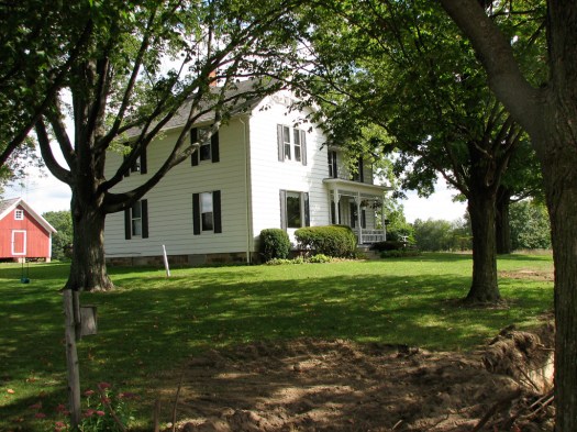
They live in a rural area between a couple of small towns. I follow dirt/gravel country roads flanked by overhanging trees to get to their home.  They’re not home (Roger told me they had a meeting they had to go to) so I sit out on the front porch on the porch swing and enjoy the view of the fields under cultivation, the neighbor’s barn and Roger and Jane’s beautiful home.

After a while their niece’s husband comes by to collect me (Roger had called him and told him I’d probably be there) and take me to his home just down the road. He built this beautiful home himself and the woodwork, of which there is a lot, was made with wood from trees harvested off his father’s property. He feeds me dinner and we talk about my travels before Roger and Jane come by to take me back to their home. Roger grew up in this home. It was his grandparents’ and his parents’ before him. We talk for a while before I shower and crash into bed.
11 September 2008
 We begin the day with a cup of coffee on the porch swing I was enjoying last night when I was waiting for Roger to get home. Roger spots a couple of sand cranes in the fields. Enjoying the quiet morning from that front porch and looking out over the fields with a cup of coffee refreshes the soul. Roger, Jane and I go to a nearby retirement home in Chelsea and pick up his mother, Joyce, so we can all go to breakfast and we have a great time getting to know each other. Over the years we’ve seen each other at major family functions and I’d just seen them all at a wedding a couple of months ago, but we’ve never really have much of a chance to talk. I so appreciate the time to get to know them a little.
I ask Roger about farming because my ignorance on the topic is extensive. I had heard that the small family farm was just about dead but I was seeing lots of what appeared to be little farms. Although, because the fields are broken up into smaller sections and there are farm houses, barns and silos scattered around, it gives the appearance of small farms, Roger, probably like many others, rents his land out to a farmer who has enough land under cultivation that he can take advantage of the economies of scale.
I also learn that the small bushy crop I couldn’t identify is soybeans. They wait until the corn is brown and dry before harvesting. That makes it easy to harvest by machine. If it is to be used for silage everything is chopped up and stored in silos where it’s allowed to ferment. Roger tells me it smells horrible but the cows love it.
Nearby is the Glazier Stove Factory in Chelsea and the building looks so unique I take a picture.
Roger helps me find a motorcycle shop that’s on my route and I call to confirm they have the right size tire in stock and their service department has the time to squeeze me in and install it. I pack up the bike, say good-bye, and I’m off to the shop where they get me right in and change the tire. The irony is that I have a new rear tire sitting in my garage at home that I purchased at discount through the internet so it’s frustrating to pay full retail but… I didn’t have much choice.
I get back on the expressway and head for the Indianapolis Motor Speedway. My original plans in Indianapolis had been to stay with my friend, Larry. He wanted to attend the MotoGP race, too and had invited me to stay with him. His house was on the market but it wasn’t selling so we thought it wouldn’t be a problem. We thought wrong. He sold the house and at the last minute, before I left home, I called the Speedway, bought a camping ticket, and had them place it at will-call for me.
After wandering around the Speedway in pre-race traffic and asking directions I made my way to the administration building where the will-call tickets were held. As I walked up the building my heart sank as I watched people in front of me trying the doors and finding them locked. Another couple, just leaving, told me they closed at 6:00 (it was now 6:06) they’d seen the guard at the door unlock the door for somebody else and tell them that they were the last ones who would be allowed in.
Since I had no place to stay without the tickets they were holding I determined to try. The people inside were generally ignoring me but I got one person to come to the door to tell me to go away. I explained my situation and she went off to see if there was anybody still there who could help. Eventually they found somebody and I got my camping tickets. Whew!!
I went across the street and they led me to a little patch of grass where I could set up my tent. It was sprinkling off and on but stayed pretty much dry while the tent went up. I met my neighbors, one of whom was a cardiologist from Emory University who’d come out on his bike and another was a couple who lived not far from me in Paso Robles, California. They flew out for the race and rented a car. I then got in touch with Larry and we made arrangements to meet the following morning.
12 September 2008
Although it was not without difficulty, Larry did find me and we went across the street to the Speedway. Larry’s been there many times since, not only does he live in the area, but his wife used to work there during races. Before her death she was a physician and was a part of the Speedway’s medical team during races so Larry could get free tickets and is very familiar with the facility. It’s my first time, and I’m mightily impressed. Compared to Laguna Seca there is a LOT of infrastructure. It is definitely an impressive facility. The track at Laguna is more interesting since it’s set in hilly country and takes full advantage of the hills to create an exciting track, but the facility at IMS is much better. Indiana geography doesn’t lend itself to much of anything except a track laid out on perfectly flat ground.
We wander the grounds and displays. Larry is attracted to some of the trikes and sidecar rigs on display. We go into the museum on-grounds and ogle their very impressive collection of race cars and racing memorabilia.


The 6-cylinder, 447 cubic inch, number 32 Marmon “Wasp” won the very first Indianapolis 500 in 1911.
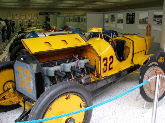
All the other racers had mechanics who rode in the vehicles as passengers but the Wasp’s driver, Ray Harroun, didn’t. The other drivers complained he was a safety hazard, because, without a passenger to alert him he wouldn’t know when other race cars were coming up behind him or passing him. In response, he built what many consider to be the first-ever rearview mirror on a car. In the picture it’s the large triangular item on four legs directly in front of the driver.
The number 8 National, driven by Joe Dawson, won the race in 1912 at an average speed of 78 MPH, with the largest engine ever used in a winning car at Indy – a 490 cubic inch 4 cylinder.

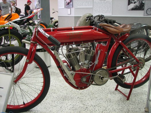
And, of course, they have the Indian racing motorcycle (which had no brakes, no front fender, pedals and a double chain drive) that won the first race at the Indianapolis Motor Speedway in 1909. Cannonball Baker won that race.
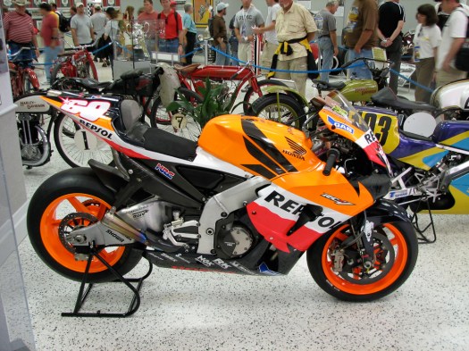
Also on display, for comparison, is a current racing motorcycle — one of Nicky Hayden’s number 69 MotoGP bikes.
It’s still raining. I hear that (even this far north) the rain is part of hurricane Ike. This track is new to all the MotoGP riders (except Suzuki wild-card rider Ben Spies) so during practice today they’re trying to learn the track. Wet weather expert Chris Vermeullen tops the time charts with Anthony West with times in the 1:54’s.
Larry tells me that the apartment he ended up with has two double beds so, if I want, I can stay with him. It doesn’t take me long to break up camp, load up the bike and follow Larry to his temporary digs in north Indianapolis. We stop for dinner on the way. I’m following Larry on my bike so enter the restaurant with all my gear. After eating, as I’m gathering up my stuff, the lady sitting next to us asks me about my bike. Her husband, who is with her but was encouraging her not to say anything to me, had to give up riding and she misses it terribly. She said that when he came home from work on Friday and found the lawns already mowed, he knew that meant he was going to take her for a ride. We talk about riding and I can see the sparkle in her eyes as she talks. Once again, I’ve been able to connect with people because I’m on a motorcycle.
13 September 2008
Today starts out sunny, but I’ve learned not to trust the weather around here. As it turns out the sun sticks around for the entire day. Larry and I watch most of practice and qualifying from one of the fences in the infield. I did get reserved seats and am happy with their location. There’s a large video monitor right across from us so we can easily see the action on the rest of the track when the bikes are out of our direct view. We’re right in front of turn 1 with a good view of the infield turns 2, 3 and 4. Turn 1 is a very gradual 140 mph sweeping left-hand turn that takes the riders off the oval and into the infield. Turns 2 and 3 are slower 90 degree right-handers and turn 4 is a very slow left-hand hairpin that returns riders to the oval. Turn 2 seems to be a problem for many of the smaller bikes who appear to be carrying too much speed through turn 1 to negotiate turn 2 and many of them low-side into the grass.
We watch much of the action from the infield fence.
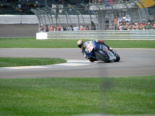

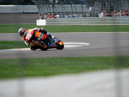

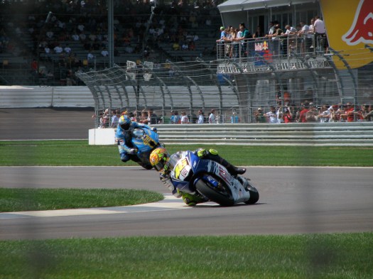
Qualifying results in the usual jockeying for position but seems to end up with Rossi on pole, Stoner second and Hayden third. I’m happy to see Nicky on the front row and we’re walking away from the fence when we discover that, at the last second, Lorenzo edged Hayden out of third. So Nicky’s going to start the race from the inside of the second row. Qualifying times dropped from yesterday’s 1:54’s to the 1:40’s. That’s a lot of time to drop, probably attributable to the combination of no rain today and greater familiarity with the track.
Larry plays tour guide to downtown Indianapolis for me and we wander around before getting dinner and returning home.
14 September 2008
Race Day! The weather is very overcast with occasional rain but it isn’t bad. I bring my umbrella but not my raincoat. We head out to the track and are there in time to watch the Red Bull Rookies race. The Red Bull Rookies are 13 to 16-year-old kids who are learning to race GP style bikes. They ride identically prepared KTM 125cc motorcycles so differences in race results are attributable to the rider. There are two groups of rookies, one for North and South America, and one primarily for Europe (although there is one American in that group).
The European contingent was totally dominant. The one rider from the American group who was a shining star was Nicky Hayden’s cousin, Hayden Gilliam. Although he had a very poor start and fell back to the middle of the pack, he fought his way back to the front and led the race for a number of laps until he crashed out. It was an excellent performance, nevertheless.
The 125cc race is held but the 250cc race is postponed until after the MotoGP race due to the weather which has taken a big turn for the worse. The rain is coming down in sheets and the wind is blowing at, what I later discover, was 60 mph gusts. Observing the flags around the track, the wind is blowing in one direction in some places but another direction in other places. Hazardous conditions for motorcycle racing. When we leave the track later we’ll find trees that have been toppled by the rain and wind. Whoever is operating the large video monitor puts up “I don’t like Ike”. You either have to be old enough or know your history well enough to get the joke.
When the rain lets up a little, track workers come out and use trucks with large brushes across the front of the truck to sweep the standing pools of water off the track. Other trucks, towing trailers with huge blowers on them drive the track blowing the remaining water off. They work the infield continuously, going back and forth for probably 30 to 45 minutes.
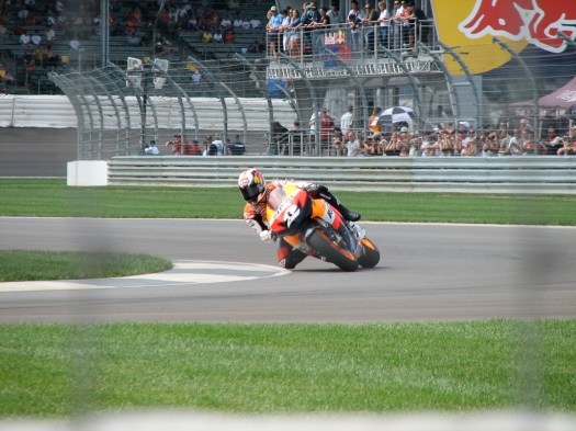
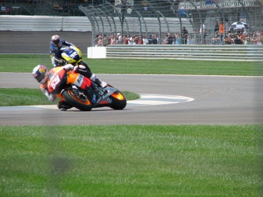
Eventually the track is declared ready and the MotoGP riders come out to a big cheer from the crowd. When the race starts, Nicky gets a great start and is in second place behind Andrea Dovizioso going through turn one. After only a few laps he’s taken over the lead but Rossi is moving up through the pack and will be a threat. The rain is starting to really come down again and the wind is picking up. Rossi takes over the lead from Nicky on lap 14 and that’s the way it ends. The race is red-flagged due to the weather conditions after 20 of the planned 29 laps.
Rossi later says he’s glad it was red-flagged and these were the worst weather conditions he’s ever raced in. Nicky takes second and Jorge Lorenzo comes in third. I feel badly for Marco Melandri who’s had a disaster of a season. For most of the race he’s running in last place. He manages to pass a couple of riders but when the race is stopped he’s fallen back to last place again. He’s a better rider than this season would indicate. The Ducati just doesn’t agree with his style.
No pictures this time. We never leave our seats. I have no desire to be out in that weather. I’m sitting in stands with a roof over my head and my seat is toward the front of the overhang, so if I were going to get rained on you’d expect it to hit me in the face. But the way the wind whips around, it’s my back that is getting wet with rain.
Afterwards, Larry takes me by the home he just sold, a very beautiful brick home, and to the cemetery where his wife, Carma and daughter, Heather are buried. We reflect on the shortness and uncertainties of life. Then it’s dinner and home.
15 September 2008
Today’s an errand day. I take advantage of having a home base to use the laundromat in the apartment complex and catch up with computer work. I call my brother in New York and our collective timing just won’t work out for me to be able to visit this time so my current plans will be to motor on over to Ohio to visit the Motorcycle Heritage Museum tomorrow, then start heading for home.
16 September 2008
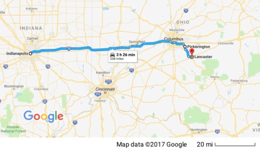
Not far from Columbus, Ohio, in the little town of Pickerington, is the headquarters of the AMA (American Motorcyclist Association) and the Motorcycle Hall of Fame Museum. Since I’m this close, I take advantage of the opportunity to visit the museum. En route I pass through Springfield, Ohio, the hometown of the world-renowned Steve O’Brien.
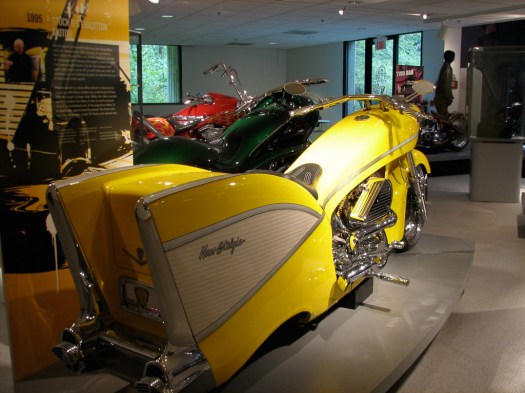
The Motorcycle Hall of Fame Museum has changing displays as well as a permanent collection. The current display is “Motorcycles of the Stars” and they have many motorcycles used in the movies, owned by movie stars, rock stars, etc.
Some are classic old bikes, like Steve McQueen’s 1926 Scott Super Squirrel.
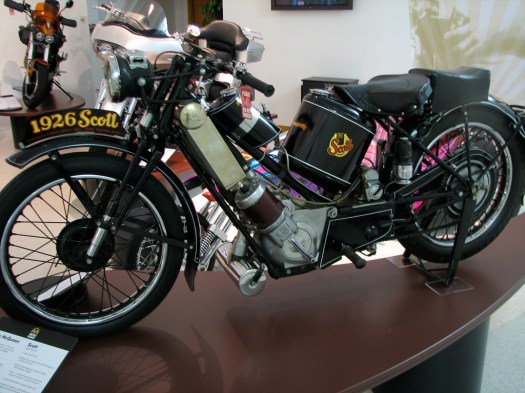
This motorcycle has actually been used several times recently in Antique Motorcycle Club of America road races.
Just to prove how very “make believe” the movies are, one of the bikes on display is a bike made to look like a Kawasaki KZ1000 police bike.
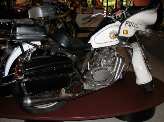
There are thousands of these bikes out there so I can’t imagine why Hollywood didn’t just get one, but, instead they took a single cylinder Honda XR500 and dressed it up to look like a 4 cylinder KZ1000. If you look at the exhaust pipes you can see that one of the pipes isn’t connected to the engine, because there isn’t a cylinder for it to connect to. This bike was ridden by a stunt rider in Terminator 2 staring Arnold Schwartzenegger.
And, of course, there’s the Captain America bike ridden by Peter Fonda in Easy Rider.

This is a duplicate because the original was crashed and destroyed at the end of the movie.
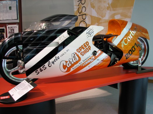
The Bonneville Racer is here because it was owned by the King of Malaysia, Sultan Iskandar Al-Haj ibni Almarhum Sultan Sir Ismail Alkahlidi, 4th Sultan of Johor, who is a motorcyclist and an avid motorcycle collector.
Arlen Ness is a famous custom bike builder and a few of his creations were in the museum including a bike built around a helicopter jet engine,
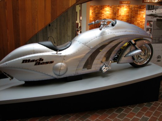
and one built to look as if it comes from the fifties, complete with fins.
And there’s a replica of where it all started, in 1885 with the Daimler “Einspur”. 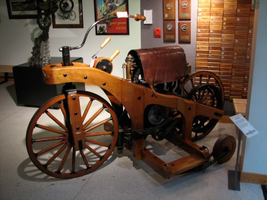 The first known gasoline engine powered cycle (though it had “training wheels”). It wasn’t really intended as a commercial vehicle but was just a test frame for an automobile engine.
My favorite bike though, is in the permanent collection. It’s the incredibly beat up Harley Davidson that belonged to David Barr. 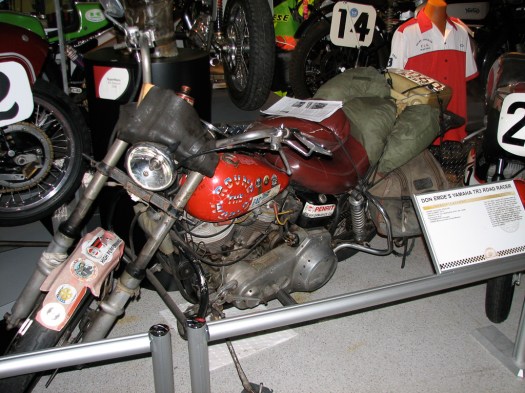 It’s my favorite because of the story that goes with it. Dave Barr was a soldier who lost both his legs to a landmine, in spite of which (or maybe because of which) he’s ridden motorcycles around the world, including across Russia in the dead of a Siberian winter across the Andes Mountains, to the Arctic Circle, through the Sahara Desert and the Australian Outback. He rode 83,000 miles in 3-and-a-half years and retired the bike with 250,000 miles on the odometer. And he did it all with no legs. You can read more about him here.
I have neither that kind of courage nor the determination. I’ve gone as far east as I have the time to go on this trip so I turn south when I leave the museum. While eating dinner a man sitting at the next table begins a conversation about riding. It turns out that Brian is also a rider and has an Aprilia and a Ducati. He’s from the area and goes over my maps with me to make some recommendations for a route. I return the favor and get out my map of Washington to recommend a motorcycle road for him on a future trip. Then I travel a little farther south before I find a campground where I can spend the night.
17 September 2008
I followed Highways 159 then 50 then the 41 south through Ohio farming country. It’s early in the morning and the fields and lakes have a low-lying fog that hangs just just above them in the cool morning air. Signs with a picture of a horse and buggy warned this was Amish country and to keep an eye out for one-horsepower vehicles. I stopped at the Seip Mound where I met Steve who was driving a compressed gas truck and was there taking a break. He was interested in the bike and, as so often happens, it turned out that he’s a rider, too. Not just a rider but a racer – mostly motocross and now super motard. We talked about motorcycles and riding before he got back in his truck to go back to work and I went to read about the Seip Mound.
The mound is a large mound of earth (240 feet long, 130 feet wide and 30 feet high) that was used for centuries by Native Americans as a burial place, probably for high ranking individuals. There were other earthworks around the mound but not many survive due to farming and erosion. Most of the artifacts recovered from the mound are from the Hopewell Indians (100BC – 500AD) but earlier artifacts have also been found.
Farther south I also stop at Serpent Mound. This is another ancient earthworks sculpture, in this case in the form of a serpent that is almost a quarter of a mile long. It is thought to have been built by the Fort Ancient culture around 1000AD. It’s built on a spur of rock overlooking the Ohio Brush Creek on the edge of a large crater. It was originally excavated between 1886 and 1889. The head of the serpent is aligned with the summer solstice sunset. I’m posting some pictures, though seeing the serpent is difficult. You can kind of see the zigzag pattern of raised earth.


There’s also a picture of a recreation of a Fort Ancient Indian hut but this one contained a rather modern artifact – a geocache logbook.
The countryside is very pastoral.
Going through both Ohio and later, Kentucky, I see lots of stars on barns and some on houses. I’m not sure what they mean but wonder if they’re related to the banner that was hung in windows during WWII to indicate a family member had given his life in the military.


Once I leave Ohio and enter Kentucky I follow the roads Brian recommended and find them to be wonderful motorcycle roads. It’s been a long time since I’ve been able to get the bike over onto the sides of the tires (except for freeway cloverleafs) but Kentucky 10 and 22 afford lots of opportunities as the road winds through the hills and hollows of northern Kentucky. There’s still a lot of agriculture and a lot of it is the ubiquitous corn and soybean fields but now, for the first time, I’m also seeing tobacco.


The fields all seem to be small and alternate with deciduous forest and hawks circle overhead. There’s little traffic but a cement truck coming the other way seems to think that the double yellow line is just a suggestion and he’s almost half way into my lane as we both round a curve going in opposite directions. I can vouch that my adrenal glands are fully functional.
As much fun as those roads are to ride they don’t allow you to cover many miles so I hop back on a major highway to get some miles under my wheels before I set up camp just outside Mammoth Cave National Park.
18 September 2008
 After breaking camp and getting breakfast I head into the national park to see Mammoth Cave. I brought my camera with every intent of taking pictures to share with you but my batteries went dead when I was inside the cave and I couldn’t take any. Sorry. It truly is impressive. You’ll just have to take my word for it.
Mammoth Cave is the longest cave in the world… by a lot. They haven’t yet mapped all of it but they have about 367 miles of connected caves and caverns mapped so far. If they combined the lengths of the second longest and third longest caves in the world, Mammoth Cave would still be about 100 miles longer than those two combined. Rainwater filtering underground carved the cave network out of limestone but most of it has a sandstone cap over the top that makes it a dry cave – water ran through the limestone carving the cave but doesn’t continue to filter down so the cave system is very stable.
The cave has an interesting history as people competed in the 1800’s to lure visitors into their part of the cave. Those who owned a part closer to town would stop cars coming up to see the cave and tell them an entrance had collapsed up the road, the cave workers had contracted TB or whatever story they could concoct to convince visitors to stop and spend their money where they were, rather than drive on by. Rock was blasted to create new entrances to the mine through which visitors could be conducted. They even told people that some feature in “their” part of the cave was a well-known named feature that was actually in somebody else’s part of the cave – such as a narrow passageway known as “fat man’s misery.”
I was interested in the fact that the Park Service now has airlocks on the entrances to keep outside air out. Apparently some of the critters living in the caves are very sensitive to temperature differences. Sorry I have no pictures.
Continuing on through Kentucky I pass close to Owensboro, known to motorcycle racing fans as the hometown of the Hayden brothers – Tommy, Nicky and Roger Lee. I’m guessing that Nicky is probably there since Indianapolis just finished and that’s only a day’s journey from his home. I, however, ride on by.
The Land Between the Lakes is a National Recreation area; a narrow strip of land sandwiched between Kentucky Lake and Lake Barkely. It’s a beautiful area and I stop at the visitor center to learn something of the area and buy camera batteries before I visit a prairie that’s being restored with native grasses and supports wild elk and bison herds. When I get there, however, I discover that motorcycles aren’t allowed so, even though I now have an operable camera… still no pictures.
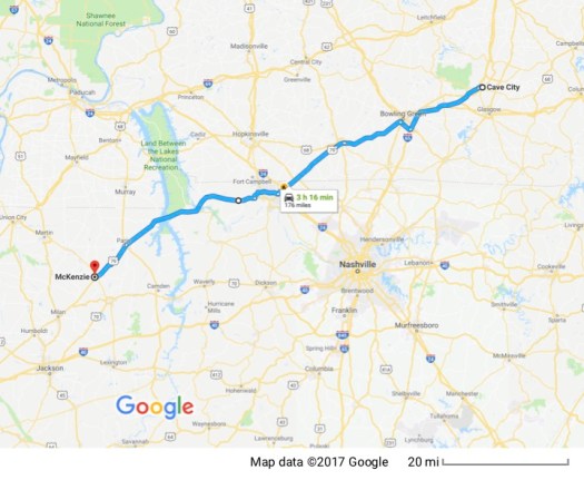
I’m not finding any campsites along my route as night falls so I stop in McKenzie, Tennessee at a motel… in large part because they advertise free internet and that will give me time to catch up on this blog. Tomorrow it’s off to Arkansas.
19 September 2008
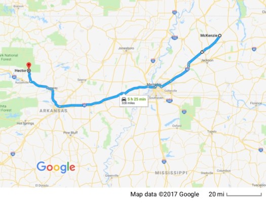 It’s a short trip down Highway 79 to I-40 which I follow through Memphis and across the mighty Mississippi into Arkansas. As I cross the border into Arkansas, the sky is looking very dark ahead of me so I pull off at the Arkansas Welcome Center just over the border to put the waterproof liners in my riding suit. It starts to rain as I’m putting everything together and I move under a picnic shelter. Before I finish, it is quickly coming down hard. I move out to the bike to cover my seat bag and tank bag. By now it’s coming down so hard and visibility is so low I decide I’m not going out. The picnic shelter is offering no protection whatsoever in this deluge… the wind is blowing the rain right under the shelter… so I ford a small pond that’s developed on the sidewalk and move into the Welcome Center as rain comes down in torrents. The staff in the center provide me with maps to peruse while I’m waiting and I use the time to decide on a route, settling on one that will take me off the freeway and into the Ozarks.
As I’m leaving the center after the rain has let up, a lady who is just coming in starts a conversation with me about the rain. She says she lives in Little Rock and that in 40 years she’s never seen it rain like that. She said that visibility was down to almost zero and “cars were hydroplaning all over the place.” I think I made the right decision to wait it out at the Welcome Center. Even if I stayed upright (which isn’t a foregone conclusion) sharing the road with hydroplaning cars doesn’t sound like fun to me.
I follow Interstate 40 continuing through more open agricultural land. While I’m stopped at a rest stop looking at a map, two ’05 ST1300’s pull up next to me. (I ride an ’05 ST1300.) It turns out there’s a gathering of ST’s planned for Eureka Springs, Arkansas that I didn’t know about. They invite me to stop by but I don’t think I can squeeze that in with everything else I have planned.
Once again I find myself wondering about town names and their source. When I was in Kentucky I went through the town of Gum Lick and have a mental image of the founder being an old man, with no teeth, who had a habit of licking his gums. Now in Arkansas I pass by Toad Suck. I’ll let you do your own imagining about the source of that name.
I continue down I-40 with the intent of getting off at highway 7 but an electronic sign on the freeway warns that 7 is closed and to use alternate routes. I get off the freeway to consult my map and plan an alternate route. I discover I’m on the 105 and that will get get me where I need to go. It’s getting dark so I stop at the Bayou Bluff Recreation Area, a National Forest Service campground on the Illinois Bayou.


I set up my tent next to Dale and Steve who, as it turns out, are local men scouting new areas to go deer hunting when the season opens. They invite me to join them at their campfire and offer to share the dinner they’re cooking over the open fire. I join them until it’s time for me to toddle off to bed.
20 September 2008
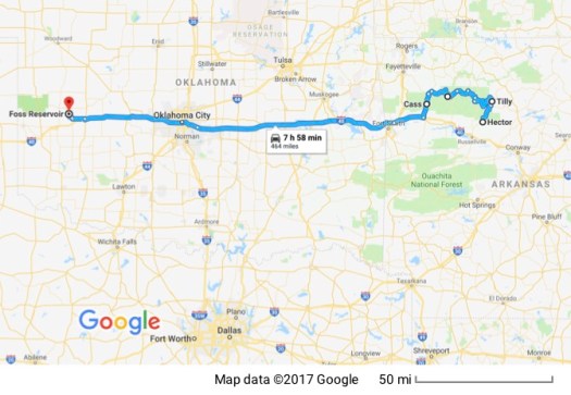
After packing up the tent and sleeping bag, I continue into the Ozarks up the 105, turning west on highway 16. The terrain goes through gently rolling hills, mostly forested with a variety of deciduous trees, with some agricultural land and some grazing land mixed in. I’m surprised at the number of small abandoned homes that have simply been left to fall into disrepair. I stop at a turnout that offers a short hike (1.7 miles) to a scenic lookout – Kings Bluff.
Stopping to eat at a little café in one of the small towns I’ve been passing through I read the local paper while I’m waiting. I learn that a 58-year-old-man was sentenced for calling up the Sheriff’s Department and telling the deputy who answered the phone that if deputies didn’t stop bothering his family he was going to shoot the next deputy that showed up. I also learn about some of the social calls that local people made on each other and see a picture of the section of road that was destroyed resulting in my detour.
I continue along the 16 enjoying the beautiful scenery and winding roads to the 23, which I follow south back to I40. I’ll be staying on I40 for a while now because I need to be at Steve and Linda’s home in Albuquerque, New Mexico tomorrow.
I pass through Fort Smith and into Oklahoma. The terrain gradually morphs into flat grassland that’s growing hay or supporting cattle. I stop for the night at a campground by a lake formed by a reservoir, Foss Lake, west of Oklahoma City. Virtually all of Oklahoma’s lakes are artificial.
21 September 2008
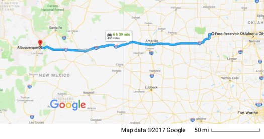 I’m packed up and on my way early this morning but eat up a lot of time getting off the freeway to take the business loop through small Oklahoma towns hoping for one of the small cafes I prefer for breakfast. Either their cafes aren’t on the main road or they don’t have any. I finally find one just before I cross the border into Texas. I find local cafes much better and more interesting than some truck stop or chain restaurant that caters to people traveling through. I enjoy the casual atmosphere, the banter between the staff and the regulars.
I cross Texas across the pan handle. There sure is a lot of open country. The terrain isn’t quite as uniformly flat as the parts of Oklahoma through which I passed but there’s little of interest to see from the freeway.
When I cross into New Mexico I move into the mountain time zone and I start seeing thunderstorms across the desert and the GPS warns of flash flood danger in the area. The first one is well to the south of me and I don’t bother putting on rain gear. The next one is north of me… still no rain gear. Then they start appearing more frequently. There’s one right ahead of me but the GPS shows the freeway makes a dogleg at Santa Rosa so I may miss it… nope. I get rained on but it’s brief and not too heavy.
Now there’s a checkerboard of thunderstorms. There’s no way I’m going to stay out of them so I get off the freeway and under a gas station roof to prepare for the rain. A rental moving truck pulls up to get gas next to me and I meet Bob and Kathy who are moving from California to Texas. Bob opens the back of the truck to show me his BMW motorcycle which he uses for traffic escort (funerals and the like). I also meet a Gold Wing rider who pulls up. He’s had his Wing for 3 weeks and already has 7,000 miles on it. He comments that he just can’t stay off it.
I continue, now prepared for rain, and enjoy the changing scenery as mesas and bluffs appear. I do get rained on but the showers are brief and don’t cause major problems. I arrive at Steve and Linda’s and we go out to dinner at a wonderful local restaurant that serves Southwestern food. At home it’s homemade apple pie for desert. I am suffering so…
22 September 2008
Today Steve takes me out for a tour of the area and he’s a wealth of local information. We travel through a number of the local Indian Pueblos and stop at a visitor center and museum the Jemez Pueblo have built.  As we travel through the Pueblos, many of the homes have the traditional adobe ovens in their yards in which traditional Indian fry bread is made.
 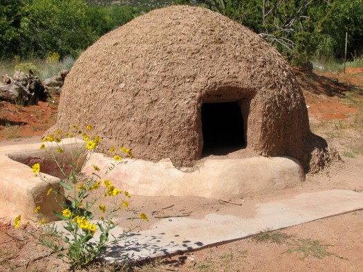 The Indians value their privacy and limit the entry of non-residents and/or prohibit pictures. The oven pictured was made at the museum for display.
We’re climbing up the side of a volcano that erupted in a tremendous explosion about 1.25 million years ago, blowing off the top of the mountain. There wasn’t any lava to speak of, but the ash that blew out of the mountain solidified and formed the volcanic rock I see today and the beautiful red rock. 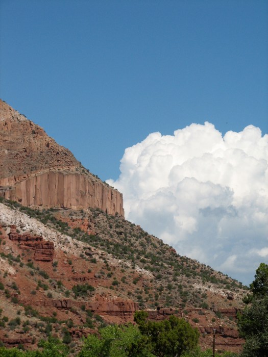
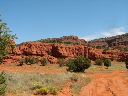 The caldera, the sunken area at the top of the mountain that was blown out by the volcano is, today, a large meadow that is a working cattle ranch. The ranch was privately owned and run since the 1600’s, the result of a Spanish land grant to the Baca family. When the Bacas wanted to sell, the federal government bought the 95,000 acre ranch and continues to run it as a working ranch. It’s also home to a large herd of elk.
We also stop to see 6 acres of land Steve and Linda own in a small community on the mountain. From the top of their property they have a beautiful view.
Having crossed the mountain we descend the other side and pick up the freeway to go home.
23 September 2008
Before I start traveling again, Steve takes me to the east side of the Sandia mountains. Steve and Linda are gastronomes and know of the most wonderful restaurants. We start the day at a little cafe where I have a wonderful omelet and I discover Steve is a philatelist. My father was a wholesaler and we talk about stamps for a while. It’s a short conversation, though, because I don’t know very much on the topic but we discover some people we know in common.
We then start up into the Sandia mountains. Foliage is just beginning to turn color and we stop frequently so I can take pictures.  Unfortunately, we’re in Steve’s car to facilitate conversation and I don’t have the spare batteries I normally carry on the bike. Yep. The digital camera’s batteries went dead and there are no stores on the mountain so I don’t have much to show you in the way of pictures. You’ll have to use your imagination. Close your eyes and picture lots of pretty fall colors splashed across a mountainside.
We return home and I get ready to leave but not before taking a picture of Steve and Linda’s stable of bikes. This is what you can do in a family with two riders and no kids. From right to left is a Honda ST1100, a BMW GS, a Honda Varadero (there’s a story behind that one… Honda doesn’t import or sell it in the US) and a Kawasaki KLR.
I’m back on I40 enroute to Flagstaff (or a little farther if I can make it farther before dark). I enjoy the wide open spaces of the desert when it isn’t just flat land with no visual variation. Traveling along this section of I-40 I’m paralleling what seems to be a continuous bluff of red earth to the north topped by the typical flat mesa. The gray/green of the desert grasses on the desert floor, punctuated by the darker green of the juniper bushes scattered across the desert with the deep red of the bluffs, framed by a clear blue sky which is, itself, punctuated with numerous small white clouds is a feast for the eyes.
Eventually those bluffs do end and I cross into Arizona, eventually rising out of the desert, into the mountains and the conifers. The smell of the pine as I ride through is welcome. I decide I’m not going to spend time searching out a picturesque campsite and just follow the freeway sign to a KOA.
24 September 2008
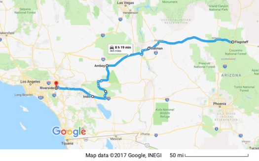 Although I could basically follow I-40 almost all the way home, I decide to vary the route. I leave Flagstaff and have breakfast at a Route 66 diner in Williams where the waitress asks me if I want the booth with the ocean view. While I’m eating I read the local paper and learn the famous steam train from Williams to the Grand Canyon is being sold and the steam train is being retired… to be replaced by a diesel. Purportedly for environmental purposes.
I stay on I-40 until I reach the Oatman Highway, a lengthy section (probably about 50 miles or so) of the old Route 66. I turn off I-40 and onto Route 66, passing through the long, flat Sacramento Valley before I reach the Black Mountains.

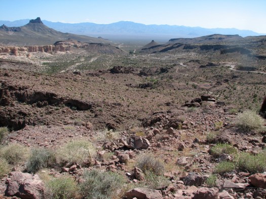
I-40 detours around the Black Mountains. Probably a wise choice if you want to make good time, but Route 66 went right through them. I’m amazed that a narrow, 2-lane road with numerous 10 or 15 mph switchbacks was such a major east-west highway. If you look to the right of the picture above of the Black Mountains you can see the road snaking up the valley. There were many places I would have loved to have stopped and photographed but there was simply no place to stop.
Oatman is an old mining town that got its start in 1915 when prospectors hit gold and about $10 million of the metal was pulled out of the hills. 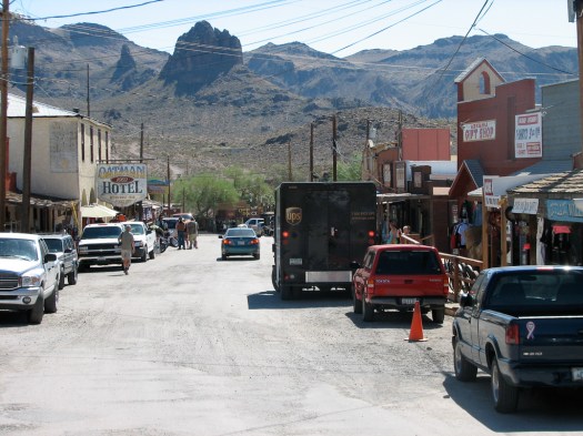 The gold the town gets now is in the form of tourist dollars. It’s remade itself as a tourist trap for travelers interested in Route 66 and makes the most of is Old West character. I happen to get there as a humorous “gun fight” is being staged. The actors stop a tour van trying to drive through town (yes I’m sure this was impromptu and not staged) and make everybody get out and watch the show. Tourists are pulled into the show and here’s a picture of one.
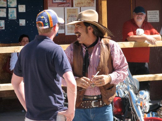
The hotel in town was the honeymoon stop for Clark Gable and Carole Lombard after their marriage in 1939 and, of course, the town still makes much of that fact. 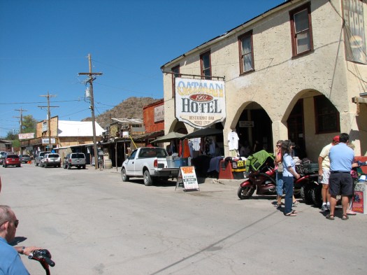 Wild burros, the descendants of pack animals turned loose by miners, roam the town freely. You can buy food for the burros who’ve learned the tourists may feed them and aren’t at all bashful about begging.
I had to take a picture of one who chose to rest in the shade of the Classy Ass Gift Shop.
After leaving Oatman, I get back on I-40 for a short distance then take Highway 95 south through the Chemeuevi Valley then to Highway 62 across the Turtle Mountains and into Twentynine Palms. I’m back in the Mojave Desert and it’s hot. The “mountains” are more like hills but clearly of volcanic origin and provide visual relief of the otherwise “sameness” of the desert. It again amazes me that human beings crossed and settled in this area traveling on foot.
I choose to turn south to go through Joshua Tree National Park and appreciate the explanatory signs posted by the side of the road. I learn that the granite boulders that I associate with the Park were formed by volcanic activity then covered over with a different kind of dark volcanic rock (Pinto Gneiss) which, when it eroded away, revealed the underlying granite. 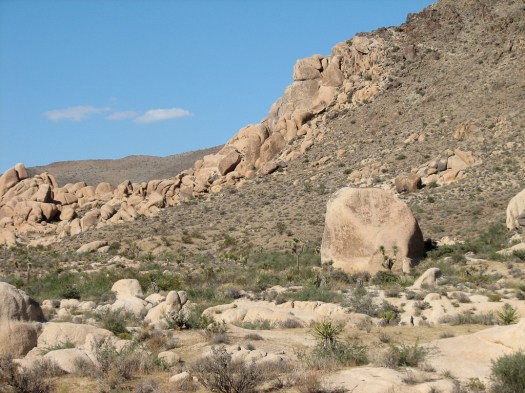 I also learn that the Joshua Trees for which the Park is named, only occur in the northern half of the Park because that part of the Park is in the southern end of the Mojave desert. The Mojave has a higher elevation than the Colorado Desert, which dominates the southern half of the Park. The cholla cactus pictured are in the lower, Colorado Desert.
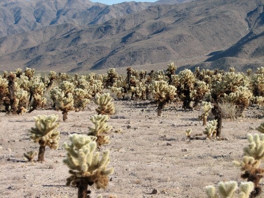
As much as I’d like to linger, it’s getting late and I want to get home. I exit the Park’s southern entrance and get on I-10 which takes me past Indian casinos, out of the desert and back home to Riverside.
Trip Statistics:
Total miles traveled – 9,102
Average miles per travel day – 364
Average miles per gallon – 40
Highest Priced Gas (Premium) – $6.435Canadian/ gal at Saskatchewan River Crossing (I converted the litres to gallons but didn’t convert the Candian dollar to US dollar because I’m not sure of the exact exchange rate but it’s in the ballpark of $.95 Canadian to $1 US)
Lowest Priced Gas (Premium) – $3.519 in Oklahoma
Lowest temperature ridden through – 2C Banff National Park
Highest temperature ridden through – 111F Chico, California
Biggest temperature range ridden through in one day – 62 degrees F (46F in Flagstaff, 108 in Indio… at 5pm!!)
Total Days on the Road – 31
I hope you had half as much fun following this trip as I had taking it. I rode through rain and snow, heat and cold, sunshine and fog; and I’d do it again in a heartbeat. I learned a lot and am left with the overwhelming feeling of being blessed. I’m blessed to be able to travel like this. I’m blessed with the health, strength and time to be able to explore this beautiful world; doubly so to be able to do it on a motorcycle. I’m especially blessed with amazing friends and relatives who took me in and added immeasurably to the joy of this trip. Thank you to all of you.

Wonderful
LikeLike